Mapserver Revisited
November 8, 2012
Years ago, before they invented Google Earth and Bing Maps and all that, I did some work to show GPS data using Mapserver. At work yesterday I was forced to revisit it while maintaining an aged and creaking part of our product. It took a while to get my head back into the right state but once I’d got going I started to enjoy it again. This time around, because I’m at work, I’m using found here.
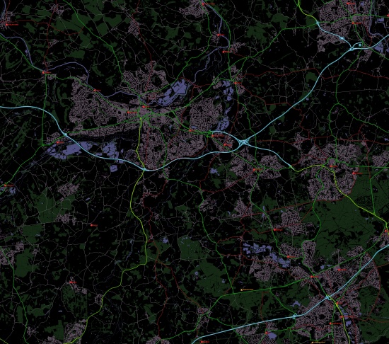
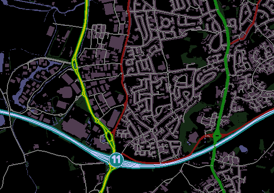
When I last played with Mapserver there was very little decent data. I had to settle for a very low resolution map of the world (vmap0) and some pretty poor raster data. Yesterday, after a little googling, I found that OS have released reasonable online tutorials too. I spent a little time getting this to render and the results are shown here in the scaled image above and full-size image below.
I decided to go with a black background as I was thinking of a Raspberry Pi based “GPS” system to show The Duke’s location on a small screen.
Note that the image is a little jagged looking. Turns out you can fix this by adding the following snippet into your map file (under the MAP element). Of course, you pay a high price in processing time and image size.
[sourcecode] OUTPUTFORMAT NAME png DRIVER “AGG/PNG” MIMETYPE “image/png” # Change to IMAGEMODE RGBA for transparent background IMAGEMODE RGB EXTENSION “png” FORMATOPTION “INTERLACE=OFF” END [/sourcecode]
The benefit of Mapserver over Google or Bing maps is that it works on local data with no requirement for an internet connection. This means it’s more reliable for a GPS sort of system. Of course, the downside is that there are fewer layers available and you have to do a lot of coding. Was good to play with, though, and I hope to get it working on the raspberry soon.
Here’s my (large) Map file:
[sourcecode] MAP IMAGETYPE PNG #Whole UK would be… #EXTENT 0 0 660000 1230000 # SU Grid is… #EXTENT 400000 100000 500000 200000 # The top right of SU is… EXTENT 450000 150000 500000 200000
FONTSET "C:\Users\Dan.Taylor\Desktop\Mapfiles\Fonts.txt"

SIZE           6400 6400
IMAGECOLOR     0 0 0
CONFIG "MS_ERRORFILE" "C:\Users\Dan.Taylor\Desktop\Mapfiles\Errors.txt"
CONFIG "CPL_DEBUG" "ON"
CONFIG "PROJ_DEBUG" "ON"
DEBUG 5

SYMBOL
	NAME "triangle"
	TYPE vector
	POINTS
		0 1
		0.5 0
		1 1
		0 1
	END
	FILLED TRUE
END

LAYER
	NAME         Woodland
	DATA         "C:\Users\Dan.Taylor\Desktop\SU\SU_Woodland"
	STATUS       default
	TYPE         POLYGON

	CLASS
		STYLE
			COLOR 20 40 20
		END
	END
END

LAYER
	NAME         SurfaceWater
	DATA         "C:\Users\Dan.Taylor\Desktop\SU\SU_SurfaceWater_Area"
	STATUS       default
	TYPE         POLYGON

	CLASS
		STYLE
			COLOR 80 80 128
		END
	END
END

LAYER
	NAME         TidalWater
	DATA         "C:\Users\Dan.Taylor\Desktop\SU\SU_TidalWater"
	STATUS       default
	TYPE         POLYGON

	CLASS
		STYLE
			COLOR 60 60 100
		END
	END
END

LAYER
	NAME         Buildings
	DATA         "C:\Users\Dan.Taylor\Desktop\SU\SU_Building"
	STATUS       default
	TYPE         POLYGON

	CLASS
		STYLE
			COLOR 80 60 80
		END
	END
END

LAYER
	NAME         Foreshore
	DATA         "C:\Users\Dan.Taylor\Desktop\SU\SU_Foreshore"
	STATUS       default
	TYPE         POLYGON

	CLASS
		STYLE
			COLOR 80 80 128
		END
	END
END

LAYER
	NAME         Roads
	DATA         "C:\Users\Dan.Taylor\Desktop\SU\SU_Road"
	STATUS       default
	TYPE         LINE

	CLASSITEM	"CLASSIFICA"

	CLASS
		EXPRESSION	 "Motorway"
		STYLE
			COLOR 20 128 128
			WIDTH 8
		END
		STYLE
			COLOR 200 200 255
			WIDTH 2
		END
	END
	CLASS
		EXPRESSION	 "Primary Road"
		STYLE
			COLOR 20 128 20
			WIDTH 6
		END
		STYLE
			COLOR 200 200 0
			WIDTH 2
		END
	END
	CLASS
		EXPRESSION	 "A Road"
		STYLE
			COLOR 20 128 20
			WIDTH 6
		END
	END
	CLASS
		EXPRESSION	 "B Road"
		STYLE
			COLOR 128 20 20
			WIDTH 4
		END
	END
	CLASS
		EXPRESSION	"Private Road, Publicly Accessible"
		STYLE
			COLOR 128 128 128
			WIDTH 2
		END
	END
	CLASS
		EXPRESSION	 "Local Street"
		STYLE
			COLOR 128 128 128
			WIDTH 2
		END
	END
	CLASS
		EXPRESSION	"Pedestrianised Street"
		STYLE
			COLOR 128 128 128
			WIDTH 2
		END
	END
	CLASS
		EXPRESSION	 "Minor Road"
		STYLE
			COLOR 128 128 128
			WIDTH 2
		END
	END
END

SYMBOL
	NAME "station"
	TYPE ellipse
	FILLED true
	POINTS
		1 1
	END
END

LAYER
	NAME         RailwayStations
	DATA         "C:\Users\Dan.Taylor\Desktop\SU\SU_RailwayStation"
	STATUS       default
	TYPE         POINT
	LABELITEM    "NAME"

	CLASS
		LABEL
			TYPE truetype
			ANTIALIAS true
			FONT arial
			SIZE 10
			POSITION cr
			COLOR 255 50 50
			OUTLINECOLOR 100 0 0
			BUFFER 30
			PARTIALS false
			FORCE true
		END

		STYLE
			SYMBOL station
			COLOR 255 50 50
			OUTLINECOLOR 100 0 0
			SIZE 20
		END
	END
END

LAYER
	NAME         Airports
	DATA         "C:\Users\Dan.Taylor\Desktop\SU\SU_Airport"
	STATUS       default
	TYPE         POINT
	LABELITEM    "NAME"

	CLASS
		LABEL
			TYPE truetype
			ANTIALIAS true
			FONT arial
			SIZE 10
			POSITION cr
			COLOR 255 180 50
			OUTLINECOLOR 100 50 0
			BUFFER 30
			PARTIALS false
			FORCE true
		END

		STYLE
			SYMBOL "triangle"
			COLOR 255 180 50
			OUTLINECOLOR 100 50 0
			SIZE 20
		END
	END
END

LAYER
	NAME         NamedPlaces
	DATA         "C:\Users\Dan.Taylor\Desktop\SU\SU_NamedPlace"
	STATUS       off
	TYPE         POINT
	LABELITEM    "NAME"

	CLASS
		LABEL
			TYPE truetype
			ANTIALIAS true
			FONT arial
			SIZE 10
			POSITION cc
			COLOR 255 50 50
			OUTLINECOLOR 100 0 0
			BUFFER 30
			PARTIALS false
			FORCE true
		END

		STYLE
			SYMBOL station
			COLOR 255 50 50
			OUTLINECOLOR 100 0 0
		END
	END
END

LAYER
	NAME         MotorwayJunctions
	DATA         "C:\Users\Dan.Taylor\Desktop\SU\SU_MotorwayJunction"
	STATUS       default
	TYPE         POINT
	LABELITEM    "JUNCTIONNU"

	CLASS
		LABEL
			TYPE truetype
			ANTIALIAS true
			FONT arial
			SIZE 14
			POSITION cc
			COLOR 200 200 255
			OUTLINECOLOR 200 200 255
			BUFFER 30
			PARTIALS false
			FORCE true
		END

		STYLE
			SYMBOL station
			COLOR 20 128 128
			OUTLINECOLOR 200 200 255
			SIZE 30
		END
	END
END
END [/sourcecode]